
12 Days in Guatemala: Atitlán to Livingston
This itinerary focuses on regional contrasts, moving from the western highlands to the eastern lowlands. We mix the indigenous textile traditions of Lake Atitlán with the Mayan architecture of Tikal, using private boats along the Rio Dulce to connect you to the unique Garifuna culture of Livingston.

The itinerary leaves Guatemala City and climbs west into the pine forests of the Sierra Madre mountains. The road descends into the Sololá department to reach Lake Atitlán, a 340-meter-deep water basin defined by the San Pedro, Tolimán, and Atitlán volcanoes. Kaqchikel and Tz’utujil Maya towns sit along the shoreline, where farmers utilize the volcanic soil to cultivate white corn and black beans.
Moving north into the Alta Verapaz department, the climate changes entirely inside the cloud forests of the Biotopo del Quetzal. The Cahabón River cuts through the limestone here, feeding the Lanquín Caves and filling the terraced natural pools at Semuc Champey. Dropping into the Petén lowlands, the thick canopy of the Maya Biosphere Reserve surrounds the stone plazas of Tikal. The trip concludes on the Caribbean coast, traveling the Río Dulce canyon by boat to reach the Garífuna town of Livingston.
Antigua Guatemala
Step into colonial splendor
Semuc Champey
Where water meets wonder
Rio Dulce
Your Caribbean getaway
Tikal
Where pyramids meet the sky
Guatemala: Trip Highlights
In the western highlands, small boats cross Lake Atitlán to connect quiet shoreline towns. San Juan La Laguna provides a close look at local weaving cooperatives and art galleries. Up in the higher elevations, the Chichicastenango market takes over the town square twice a week. Vendors set up their stalls to trade hand-woven textiles and fresh produce right on the steps of the Santo Tomás Church.
The city of Cobán provides a base to reach the Grutas de Lanquín (a network of limestone water caves) and the protected pine-oak reserves of Baja Verapaz.The walking trails of the Biotopo del Quetzal run through the protected mountain reserve where you look for the Resplendent Quetzal bird. At Semuc Champey, wooden viewpoints overlook the cascading pools, and the surrounding dirt paths lead to the exact spot where the Cahabón River plunges underground.
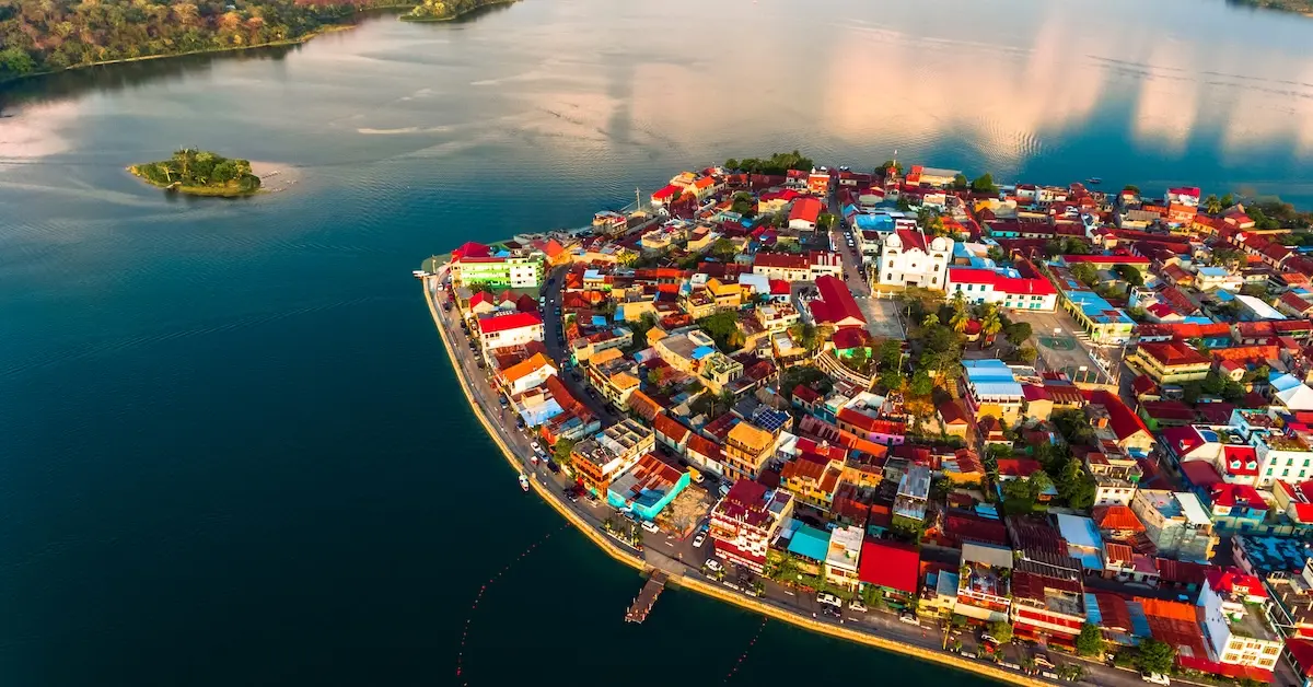
The northern route leads into the deep jungles of the Petén department and the Caribbean coast. The wooden stairs of Temple IV in Tikal climb above the tree canopy. Traveling down the Río Dulce, rock canyons covered in ferns lead directly into Livingston. Sitting by the water, a bowl of Tapado, a traditional coconut seafood stew, highlights the coastal culture.
Your 12-Day Guatemala Itinerary
Day 1: Guatemala City, Lake Atitlan
Upon landing at La Aurora International Airport, your guide meets you in the arrivals hall to begin the journey into the Western Highlands. The drive west along the Inter-American Highway takes roughly three and a half hours to cover 115 kilometers. The road passes through the commercial hub of Chimaltenango as the elevation gradually increases.
Driving down into the Sololá area, the road drops away, giving you a completely clear look at Lake Atitlán, a massive crater lake entirely surrounded by the imposing peaks of the San Pedro, Tolimán, and Atitlán volcanoes. Your driver pulls directly up to your lakeside hotel to check in and rest.
- Two nights in Lake Atitlan.
Day 2: Santa Catarina Palopó, San Juan, San Marcos
The morning starts on the docks of Panajachel, where you board a small boat for the 8-kilometer ride across the lake to Santa Catarina Palopó. On the way over, the deep water reflects the slopes of the Tolimán volcano. Walking up from the docks, the narrow streets reveal block houses painted in a bright blue wash. A community project uses these murals to highlight local plants and the pepesca fish, drawing inspiration from the patterns woven into the women’s traditional clothing. Along the hillside paths, residents harvest tall grasses from the shoreline to weave petate (traditional woven floor mats).
A 15-minute boat ride continues to San Juan La Laguna. Walking up the hill from the wooden pier, the walls are covered in bright murals showing local Tz’utujil creation stories. This village is highly regarded for its artistic culture and is a primary draw for visitors. The path passes local art galleries displaying overhead, bird’s-eye view oil paintings of the lake before stopping at a textile cooperative. The town is highly organized, and weavers demonstrate how to extract natural dyes from tree bark and the sacatinta plant to color raw cotton threads.
A final 15-minute boat transfer reaches the docks of San Marcos La Laguna. Walking 300 meters up the path away from the water accesses the primary Kaqchikel community center. The main plaza contains a large ceiba tree casting shade over the municipal basketball court and the Catholic church. Designed without paved roads, the town relies on dirt footpaths passing avocado orchards and small cafes. You walk the small dirt paths, experiencing the quiet, yoga-focused atmosphere. The peaceful shoreline provides a calm space away from the main boat docks to look out at the water.
Day 3: Chichicastenango, Antigua Guatemala
Driving the 40 kilometers of mountain roads up to Chichicastenango requires about an hour and a half. Inside the municipal market, wooden poles and canvas covers create a tight maze of stalls. Vendors here trade fresh produce, carved cedar masks used in the traditional Dance of the Conquest, and tightly woven huipiles (traditional cotton blouses woven on backstrap looms).
At the edge of the square stands the white facade of the Santo Tomás Church, built in 1545. Vendors set up their stalls to sell bright flowers and colorful textiles right on the 18 front steps of the church. Inside the building, Catholic saints line the walls while the floor is covered in pine needles and maize for traditional Maya ceremonies.
Dropping out of the high mountains to reach Antigua Guatemala takes two and a half hours, covering 80 kilometers. A short orientation walk through the cobblestone streets of the Panchoy Valley introduces the city layout. The Iglesia El Carmen sits near the center, displaying a ruined brick facade. The remaining plaster columns, bearing intricate floral carvings, survived historical earthquakes and demonstrate the city’s architectural resilience.
- Two nights in Antigua Guatemala.
Day 4: Antigua Guatemala, Volcano Pacaya
The morning walking route begins in the geometric center of the city at the Plaza Mayor. The tree-lined pathways of this square border the Palacio del Ayuntamiento, where a double-tiered stone arcade runs the entire length of the northern block. Walking across the eastern edge of the plaza reaches the San José Church. Behind the active white plaster building, dirt paths enter the roofless ruins of the original 1541 cathedral, passing between exposed brick pillars and descending into the open lower-level crypts.
Heading north along 5a Avenida Norte, the cobblestone street passes beneath the Santa Catalina Arch. A 19th-century French clock sits at the top of this yellow structure, which spans the width of the avenue to link the convent to a neighboring property. At the northern end of the avenue sits the Iglesia de La Merced. While the yellow and white baroque facade faces the street, walking inside accesses the convent ruins. The center of this open-air courtyard contains the Fuente de Pescados (Fountain of the Fish), a 27-meter-wide stone water basin shaped like a water lily.
A 400-meter walk east accesses the Convento de Las Capuchinas. Built in 1736, the complex contains the Tower of Retreat, where 18 private nuns’ cells sit arranged in a circle around a center pillar. The lower-level choir rooms and the communal bathing areas offer a clear look at the daily life of this historic order. Walking south along 4a Calle Oriente, the wooden display cases at Dulcería Doña María Gordillo display trays of traditional canillitas de leche (soft milk candies) and tamarind sweets prepared in copper pots.
For the afternoon excursion, it takes about an hour and a half to drive the 35 kilometers to the San Vicente Pacaya volcano. The hike starts at 1,900 meters on dirt paths through local farmland before entering the pine forests. The ascent takes roughly an hour and a half to reach the base of the Cerro Chino cone. The trail leads straight out onto the cooled lava fields from the 2010 and 2014 eruptions. At “Los Hornos,” natural heat vents escape from the earth, acting as a volcanic oven to roast marshmallows on wooden sticks. Looking west, the ridge provides clear views of the Agua, Fuego, and Acatenango volcanoes.
Hiking back down to the start of the trail takes an hour. A short 15-minute drive reaches Kawilal Hot Springs. The outdoor complex contains 12 thermal pools, three steam baths, and three hydrotherapy baths heated naturally by the volcano. After resting in the warm water, you take the hour-long drive back to Antigua. The evening concludes at the atrium outside La Merced church, where local vendors set up grills to prepare pupusas (thick corn tortillas stuffed with cheese and pork) and sweet atol de elote (a warm, thick corn traditional beverage).
Day 5: Biotopo del Quetzal, Coban
Heading north out of the Panchoy Valley on the main northern highway, the 160-kilometer route takes about four hours. The landscape transitions from the dry Motagua valley into the mist-covered mountains of Baja Verapaz. The Biotopo del Quetzal sits along the road, a 1,044-hectare protected reserve in Purulhá.
Inside the Biotopo reserve, the 2-kilometer Los Helechos trail travels through the forest. The high branches serve as habitat for the Resplendent Quetzal, the famous green and red national bird of Guatemala. You walk among an ecosystem or air plants, mosses, orchids, and bromeliads thriving in the warm mountain air. Walking the uneven dirt and stone steps under the tree cover requires crossing small streams that feed into the valley below.
An hour and a half drive covers the final 50 kilometers to the city of Cobán. After checking into the hotel, the central plaza provides a quiet space to observe local commerce. The region produces high-quality Arabica beans, and the cooler highland climate is often marked by a light local drizzle known as “chipi chipi.“
- Two nights in Cobán.
Day 6: Semuc Champey, Lanquin Caves
Driving from Cobán to Lanquín takes about two hours on a paved road. In Lanquín, you switch to a local 4×4 truck for the last 45 minutes, moving over a rough dirt road down to the entrance of Semuc Champey. The exploration starts with a 45-minute upward walk, covering 1 kilometer of wooden boardwalks and dirt steps to reach El Mirador. This wooden deck looks straight down at the 300-meter limestone bridge spanning the valley, revealing the pools below.
Hiking back down to the river level takes 30 minutes. The trail leads straight to El Sumidero, the rocky opening where the violent Cahabón River disappears underground, flowing beneath the limestone bridge. The rock bridge itself holds six calm, cascading natural pools for swimming, with smooth limestone edges acting as natural slides between the upper and lower water basins.
Riding in a 4×4 truck covers the final 10 kilometers of dirt roads to the Lanquín Caves in about 30 minutes. The lit walkways go 400 meters deep into the cavern, passing between wet rock columns and the fast-moving water of the underground Lanquín River. Standing near the entrance at dusk provides a clear look at thousands of bats exiting the cave to hunt for insects in the surrounding trees.
Day 7: Crater Azul, Flores Island
The three-hour descent from Cobán covers 120 kilometers, dropping out of the mountains and into the flat plains of the Petén department. At a small river dock in Sayaxché, a motorized canoe is ready for the 30-minute ride traveling down the wide Río La Pasión before turning into the narrow Pucté stream to reach Cráter Azul.
This natural water source contains completely transparent pools with a blue tint. Jumping from the boat to swim in the clear water means floating directly above dense underwater gardens of broad-leaf water lilies. The high visibility reveals the roots, underwater limestone shelves, and fish clearly near the sandy bottom.
A 40-minute boat ride returns to the vehicle. Crossing the lowlands to reach Flores Island requires a two-hour drive covering 80 kilometers. Flores Island sits entirely within Lake Petén Itzá. You check into your hotel upon arrival. The late afternoon provides time to walk the lakeside avenue looking out at the water, or find a spot to watch the sunset over Lake Petén Itzá.
For a higher vantage point, Sky Bar provides a rooftop terrace looking directly west over the lake. The atmosphere is relaxed, with high stools facing the water, making it a popular spot to order nachos and a cold Gallo beer while watching the sky change colors.
San Telmo features mismatched vintage furniture and colorful walls right on the western edge of the island. Known for its extensive vegetarian options and creative cocktails, the outdoor seating provides a clear look at the sun setting behind the mainland mountains.
Sitting on a wooden deck built out over the water, Raíces Bar and Grill offers a more substantial dining experience. Travelers come here to eat local steaks and grilled fish, listening to the water lap against the pilings as the sun goes down.
- Two nights in Flores Island.
Day 8: Tikal, El Remate
It takes an hour and a half to drive the 65 kilometers to the Tikal park entrance. Tikal sits inside the Maya Biosphere Reserve, a large protected tropical forest that covers millions of acres in northern Guatemala, acting as a home to jaguars, howler monkeys, and thousands of hidden Maya structures. Exploring the site requires a five-hour walk covering 8 kilometers of dirt paths beneath the heavy tree canopy.
The Maudslay Causeway leads straight west to Temple IV, the Temple of the Two-Headed Serpent. Climbing the wooden staircases built into the side of the structure reaches the 65-meter summit. Standing on the highest pre-Columbian structure in the Americas, the stone steps offer a clear view of Temples I, II, and III breaking through the trees.
Walking east into the city center accesses the North Acropolis. This complex served as the royal necropolis for generations, filled with the uncovered tombs of the city’s earliest rulers. Stepping down into the trenches reveals the overlapping layers of temples, showing how different Maya kings built new structures directly on top of older ones over hundreds of years.
The afternoon walk concludes at Group G, also known as Acanmul. The inner corridors of this residential palace complex feature grooved walls designed to look like reeds. The tunnel-like masonry entrance displays a large plaster mask of a skeletal creature, showing how the Maya nobility lived away from the main ceremonial plazas.
A 35-kilometer drive takes 45 minutes to reach the lakeside village of El Remate. The 2-kilometer trails of the Cerro Cahuí reserve provide a space to scan the branches for ocellated turkeys and toucans. Walking down from the reserve to the wooden piers leads straight into the warm waters of Lake Petén Itzá for a swim. The drive back to Flores takes 30 minutes.
Day 9: El Boqueron, Castle of San Felipe
The route heads south out of the Petén lowlands, taking about three and a half hours to drive the 210 kilometers to the town of Río Dulce. From the town docks, a 30-minute motorized boat ride crosses a section of Lake Izabal to reach the mouth of the Río Sauce.
At the entrance to El Boquerón canyon, travelers transfer into a cayuco (a traditional wooden dugout canoe) rowed upstream by a local Q’eqchi’ guide. The canoe passes between rock walls rising 200 meters vertically, covered entirely in hanging ferns and vines. The water here is completely transparent, showing the smooth river stones on the bottom. The guide rows against the current until reaching the shallow rapids, where the boat stops so passengers can step out and stand in the cool river.
A boat ride returns toward the bridge to stop at the Castle of San Felipe de Lara. Built in 1652, this stone fort sits exactly where the wide lake narrows into the river. The walking route begins at the outer defensive wall before crossing the wooden drawbridge to access the central courtyard.
Inside the main structure, the paths go through low, arched brick doorways built specifically to force invading English pirates to bend down upon entering. Climbing the stone stairs reaches the Torre de Bustamante (Bustamante Tower), providing a clear look over the water where iron cannons sit mounted in the windows. Descending into the lower levels of the fort reveals the dark, damp holding cells used to imprison captured raiders. A five-minute boat transfer from the fort docks reaches the riverside lodge for the evening.
- Two nights in Rio Dulce.
Day 10: Rio Dulce, Livingston
The boat tour down the Río Dulce toward the Caribbean Sea takes up most of the day as you stop at various nature reserves along the way. The direct ride is only an hour and a half, but taking time to explore makes it a full-day experience. The boat crosses the 16-kilometer expanse of the Golfete and enters the Jardín de Lotas (Water Lily Lagoons), slowing down to move quietly through acres of floating white lily pads. Isla de Pájaros (Bird Island) sits nearby, a protected mangrove island holding white egrets, pelicans, and cormorants roosting in the branches.
Continuing downriver from Bird Island, the boat enters the Biotopo Protegido Chocón Machacas, a 7,200-hectare reserve. The water channels serve as habitat for the endangered West Indian manatee feeding on the aquatic grasses. Along the riverbanks, wooden houses built on stilts over the water appear. Q’eqchi’ Maya families live here, and cayuco vendors paddle their wooden canoes up to the boat to trade local crafts and coconuts.
Continuing toward the coast, the boat enters the Cañon de Río Dulce (River Canyon). Limestone walls rise 100 meters straight out of the water. A brief stop at the base of the canyon allows travelers to feel the hot thermal waters venting into the river before reaching the ocean.
Stepping off the boat in Livingston, you walk up from the docks to explore the town. The streets showcase brightly painted wooden architecture and a strong Garífuna culture. You can hear local drum music, learn about the Afro-Caribbean heritage, and visit a local bakery making fresh coconut bread. A local restaurant serves Tapado, a traditional coastal seafood stew prepared with a base of coconut milk, whole crabs, shrimp, plantains, and fresh cilantro. After lunch, the coastline provides a view out at the Bay of Amatique before taking the hour-long boat ride back up the river to the hotel.
Day 11: Guatemala City
The return to the central capital covers 280 kilometers from the Caribbean lowlands, taking about five hours. Back in Guatemala City, the afternoon tour starts in Zone 2 at Minerva Park to see the Mapa en Relieve. Built in 1905, this 1,800-square-meter concrete topographic map sits entirely on the ground, offering a to-scale view of the country’s mountain ranges and river systems. Standing on the raised observation platforms built next to the map, your guide points down to trace the exact physical route of the past eleven days, showing the vast distance between the western volcanoes, the Petén jungles, and the Caribbean coast you just traveled.
Moving to the Francisco Marroquin University campus in Zone 10, the Museo Ixchel del Traje Indígena documents the history of Guatemalan textiles. The exhibits here show the exact backstrap weaving techniques and regional clothing styles used by the country’s indigenous communities over the centuries.
The tour then heads to the historical center in Zone 1. You start at the Plaza de la Constitución, the central square of the city. The green stone facade of the National Palace of Culture sits on the northern edge. Originally built as the headquarters for the Guatemalan president, the halls now display national art and historical exhibits. Walking across the plaza, the heavy wooden doors of the Metropolitan Cathedral open to reveal high altars and a long central walkway flanked by thick stone columns.
From there, you walk down Sixth Avenue, a busy pedestrian street lined with historic architecture and cafes. The afternoon concludes walking through the underground pathways of the Central Market to see the local vendors trading fruit, leather goods, and flowers.
- One night in Guatemala City.
Day 12: Departure from Guatemala
Depending on the flight schedule, your driver meets you at the hotel lobby. The 5-kilometer transfer to La Aurora International Airport takes just 15 minutes. The departure terminals serve as the final stop before the flight home, carrying memories of the high volcanic mountains, the tropical jungles, and the warm Caribbean coast.
map, expenses & price
Expenses included:
-All private transportation.
-11 nights of hotel accommodations.
-Tours and excursions as listed.
-All park entrance fees.
-Professional local guides.
-Boat transfers
-Daily breakfast
CURATED TRIP EXTENSIONS
ADD-ON
Copán Ruinas: The Rosalila Temple
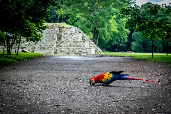
The Copán archaeological site differs completely from the towering pyramids of Tikal. Known as the artistic center of the Maya world, Copán focuses heavily on incredibly detailed stone sculptures and 3D carvings. You walk through the shaded dirt paths to reach the Hieroglyphic Stairway. This structure comprises 63 stone steps bearing the longest known text of Maya writing. The Great Plaza holds highly detailed carved stone pillars depicting former rulers. Scarlet macaws fly between the ceiba trees before the path enters the residential areas of Las Sepulturas to reveal the stone sleeping benches used by the nobility.
add-on
El Paredón: Volcanic Sand
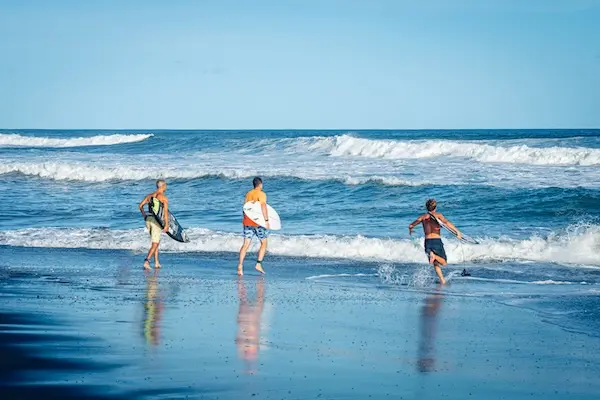
El Paredón is a coastal town focused around a wide beach of dark volcanic sand. The main attraction is the ocean itself, where consistent waves draw a laid-back surfing community. You can walk barefoot along the long stretches of sand, watch the surfers ride the strong Pacific swells, or sit at a palm-thatched cafe facing the water. For a different pace, a motorized canoe trip into the nearby Chocoyero estuary provides a chance to see the root systems of the red, black, and white mangroves and scan for feeding sea turtles breaking the surface.


